Boquete sits at 1,000 metres above sea level in Panama's Chiriquí highlands, and within a 20-minute drive of the town square you can be standing inside a cloud forest, watching a waterfall pour off a moss-covered cliff, or scanning the canopy for a Resplendent Quetzal. The trails here are genuinely world-class — and most visitors only scratch the surface.
This guide covers every trail worth your time in 2026: exact distances, elevation gains, current entrance fees, how to reach each trailhead independently, which months each trail is at its best, and where the quetzals actually are. We have also included three trails that rarely appear on the standard lists, for when you want to escape the crowds. If your Panama trip also takes in El Valle de Antón — the crater town a couple of hours from Panama City — our companion guides cover its hikes, things to do, and tours there too.
Section 01Why Boquete is Panama's hiking capital
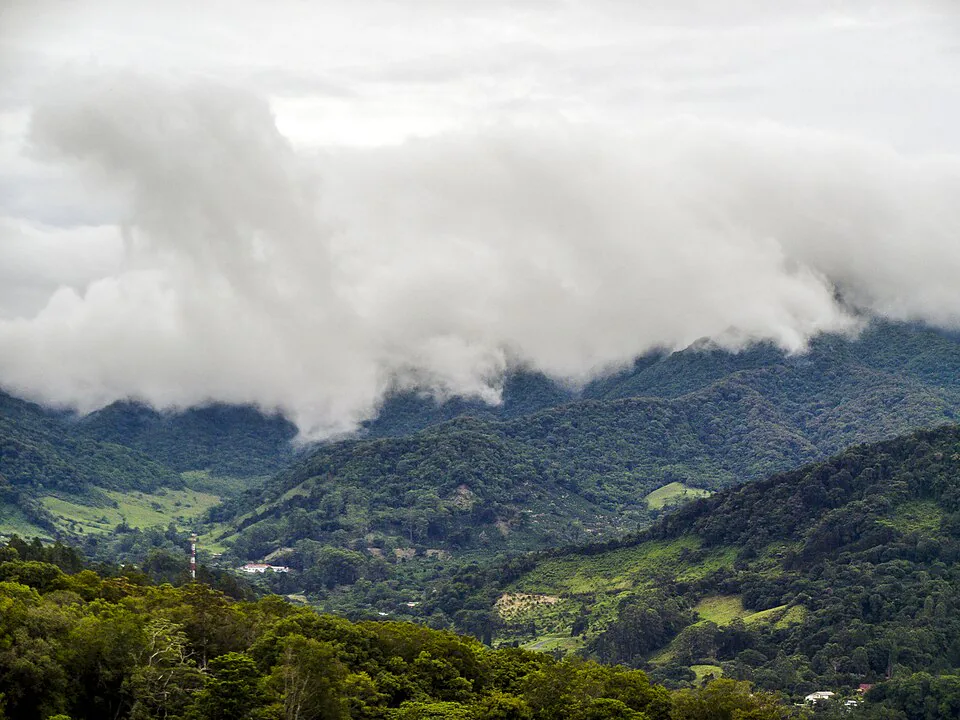
The short answer: geology and altitude. Volcán Barú, Panama's only volcano and highest peak at 3,475 m, creates a micro-climate that keeps Boquete between 16°C and 24°C year-round. That cool, moist air feeds a dense cloud forest ecosystem that blankets the slopes above town, and the same moisture that makes trails muddy also drives the waterfalls, keeps the orchids blooming, and concentrates the bird life that draws serious birders from around the world.
More than 250 bird species have been recorded in the trails immediately around Boquete, including the Resplendent Quetzal — Central America's most sought-after bird — along with five feline species, howler monkeys, sloths, and a staggering variety of orchids and bromeliads. The trails themselves range from a gentle 3 km cloud-forest walk to a 14 km overnight summit push. You can do a different hike every day for a week and never repeat yourself.
The other reason Boquete works so well for hikers is logistics. The town is compact and walkable, colectivo minivans connect the centre to most trailhead neighbourhoods for $1–2, and the trail network is dense enough that you can combine two shorter hikes into a single day without needing a car. That said, knowing exactly how to get to each trailhead — and what conditions to expect when you arrive — is where most guides fall short. We fix that below.
Section 02Trail comparison: costs, difficulty & time at a glance
Use this table to choose your trail before reading the full descriptions. Difficulty ratings below are based on elevation gain per kilometre, technical terrain (roots, scrambling, mud), and overall distance — not just a vague label.
| Trail | Distance | Elev. gain | Time | Fee (solo) | Guide needed? | Verdict |
|---|---|---|---|---|---|---|
| Lost Waterfalls | 6 km r/t | ~400 m | 2–3 hrs | $10 | No | Best first hike |
| Pipeline Trail | 6.5 km r/t | ~340 m | 2–3 hrs | $5 | No | Best for quetzals |
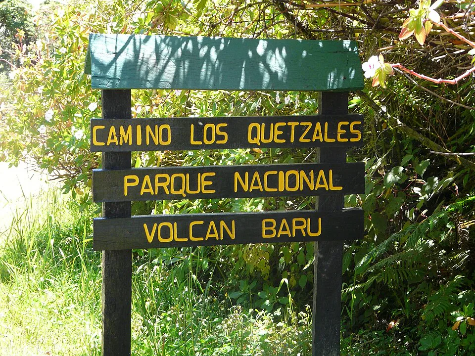
| Sendero Los Quetzales | ~14 km one-way | ~600 m gain / 1,200 m descent | 5–7 hrs | $5 (park) | Recommended | Most scenic full day |
| Volcán Barú Summit | 14 km r/t | ~1,800 m | 8–12 hrs | $5 (park) | Strongly advised | Serious undertaking |
| El Pianista | ~8 km r/t | ~600 m | 3–4 hrs | Free | No | Best cloud forest |
| Piedra de Lino | 2.6 km r/t | ~300 m | 1.5–2 hrs | Free | No | Best views, short day |
| Choclon Waterfall | ~4 km r/t | ~200 m | 1.5–2 hrs | Free | No | Best hidden gem |
Guided tours for the Lost Waterfalls and Pipeline Trail run $35–$45 per person through operators in town and include transport. For Los Quetzales and Barú, a guide adds $50–$100 but is worth it for navigation and safety, especially in wet conditions.
Section 03Lost Waterfalls Trail (Tres Cascadas)
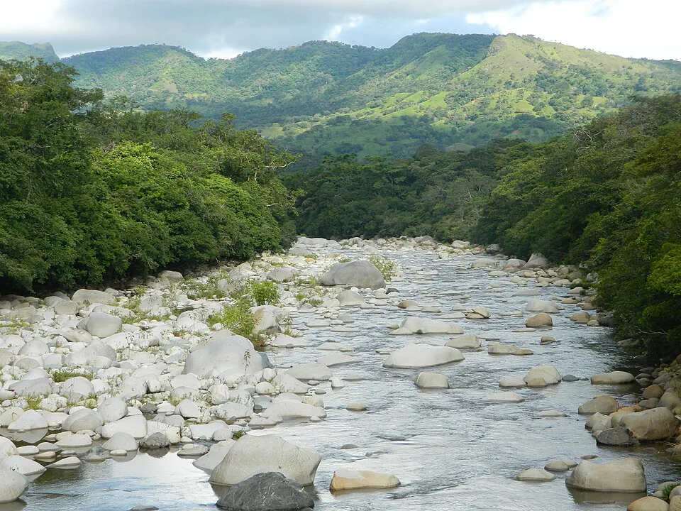
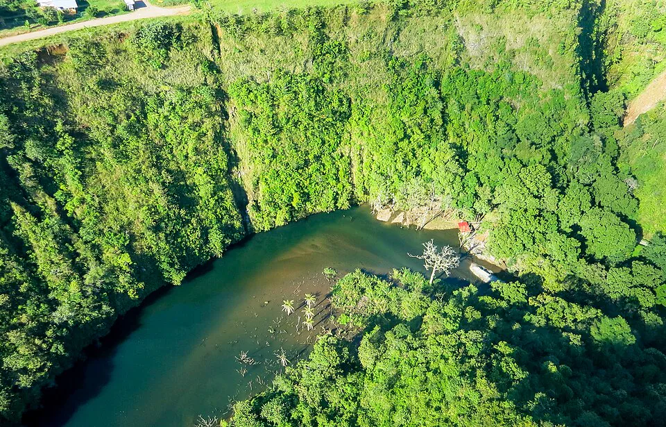
The Lost Waterfalls Trail — officially Sendero Tres Cascadas — is the trail that most visitors do first in Boquete, and for good reason: it delivers three genuinely impressive waterfalls, dense cloud-forest scenery, suspension bridges, and a manageable challenge, all within a 2–3 hour window. The entrance fee is currently $10 per person (up from $7 in earlier years), paid at a staffed booth near the trailhead. The trail is on private land and is well maintained by the landowners.
The numbers
- Distance: ~6 km out-and-back (some sources say 3.2 km one-way)
- Elevation gain: ~400 m over the full round trip
- Difficulty: Moderate — steep in places, with exposed roots and ropes on the upper section between the second and third falls
- Time: 2 hours for fast hikers; 3 hours at a comfortable pace with stops
- Best season: December–April for drier, firmer trails; accessible year-round but expect mud and slippery ropes in the wet season (May–November)
The three waterfalls, in order
The Lower Falls arrive after about 20–25 minutes of hiking. They pour into a narrow canyon — scenic but no swimming due to the confined gorge. Most hikers stop here for photos and press on. The Middle Falls are the most photogenic: a wide curtain of water dropping off a moss-covered cliff into a small pool. You can get close, but swimming is not recommended due to falling rocks. Keep your eyes open for Longhorn Beetles on the rocks around the pool. The Upper Falls are the reward for the hardest section of trail — steep, muddy, with fixed ropes on the worst pitches. The upper falls are the most secluded and the most dramatic. A cold plunge pool sits at the base. This section is the one most likely to be roped off after heavy rain; check at the booth before you start.
Getting to the Lost Waterfalls trailhead
From Boquete's Parque Central, catch a colectivo minivan headed to Bajo Mono from the corner of Avenida Central and Calle 1 Sur — one block north of the main square. Fare is around $1.50. Ask the driver to drop you at the Lost Waterfalls suspension bridge. Taxis from the park cost $8–$12 one-way. There is a small car park at the trailhead for 6–8 vehicles, accessible without a 4WD. The trailhead is approximately 4 km north of Boquete town centre.
Three rides. One unforgettable Boquete.
Premium Orbea e-bikes that do the climbing for you. Helmet, gloves, water and route support included — and you pay when you arrive.
Coffee Farm E-Bike Tour
Ride to a working farm and see how Geisha — the world's most expensive coffee — is made. Tasting at Altieri Specialty Coffee, geisha ice cream included.
Guided Highlights Ride
Lost Waterfalls, Library Park and the highland viewpoints locals love — the spots most visitors never find.
Self-Paced Rental
Hourly or full-day. Take a recommended route or just wander. The e-bike means hills don't decide your day.
Section 04Pipeline Trail (Sendero El Pianista / Bajo Mono)
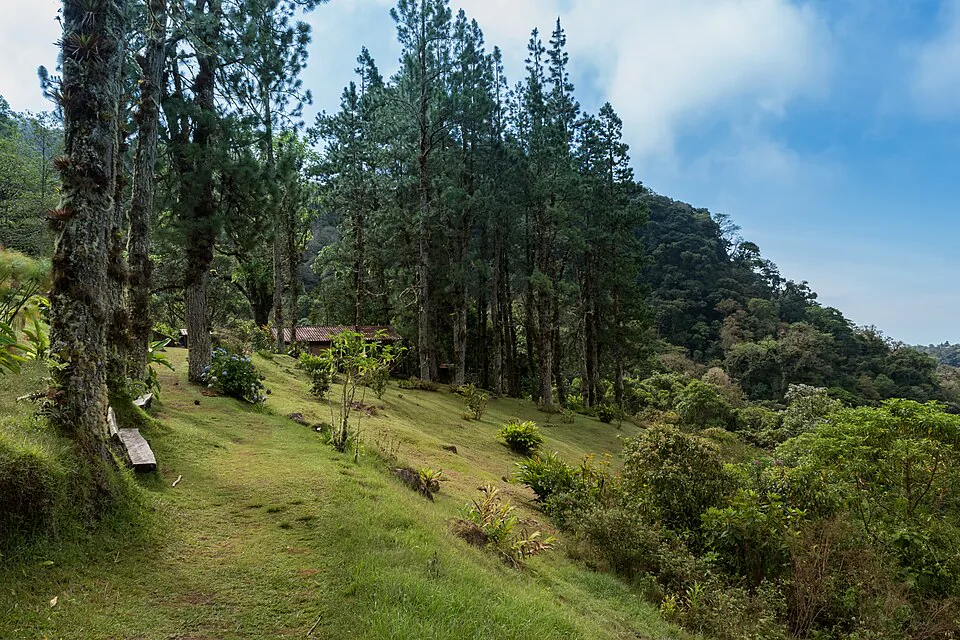
The Pipeline Trail in Bajo Mono is Boquete's best trail for wildlife — specifically for the Resplendent Quetzal — and its most accessible for families, older travellers, and anyone who wants a genuine cloud-forest experience without a punishing climb. The trail follows a river through old-growth forest to a waterfall at the turnaround point. The path is mostly flat with a gentle incline, making it more of a scenic walk than a strenuous hike.
The numbers
- Distance: 6.5 km out-and-back
- Elevation gain: ~340 m total
- Difficulty: Easy to moderate — mostly flat, some rocky sections and short river crossings
- Time: 2–3 hours
- Fee: $5 per person, paid at the landowner's house near the entrance
- Best season: January–April for quetzal sightings (nesting season); trail is pleasant year-round
What makes it special
The trail passes a tree estimated to be over 1,000 years old — a genuinely humbling landmark about halfway along. The waterfall at the end is not the most powerful in the area (it is more of a wide cascade than a thundering drop), but the setting — a hidden clearing in old-growth forest — is magical. The real draw, however, is the birdlife. The Pipeline Trail is consistently rated the best trail in the Boquete area for quetzal sightings. Multiple local guide groups operate here with spotting scopes, and even independent hikers regularly encounter quetzals in the canopy above the trail. Sloths and howler monkeys are also frequently spotted.
Getting there
Same colectivo as for the Lost Waterfalls — Bajo Mono-bound from Calle 1 Sur. The Pipeline Trail sign is visible from the road; do not confuse it with the Lost Waterfalls sign, which is nearby. There is a small car park for 5–6 vehicles. Taxis from town: $12–$16 one-way. Note: the Pipeline Trail sign reads both "Pipeline Trail" and "The Waterfall Trail" — this is correct, not a mistake.
Section 05Sendero Los Quetzales
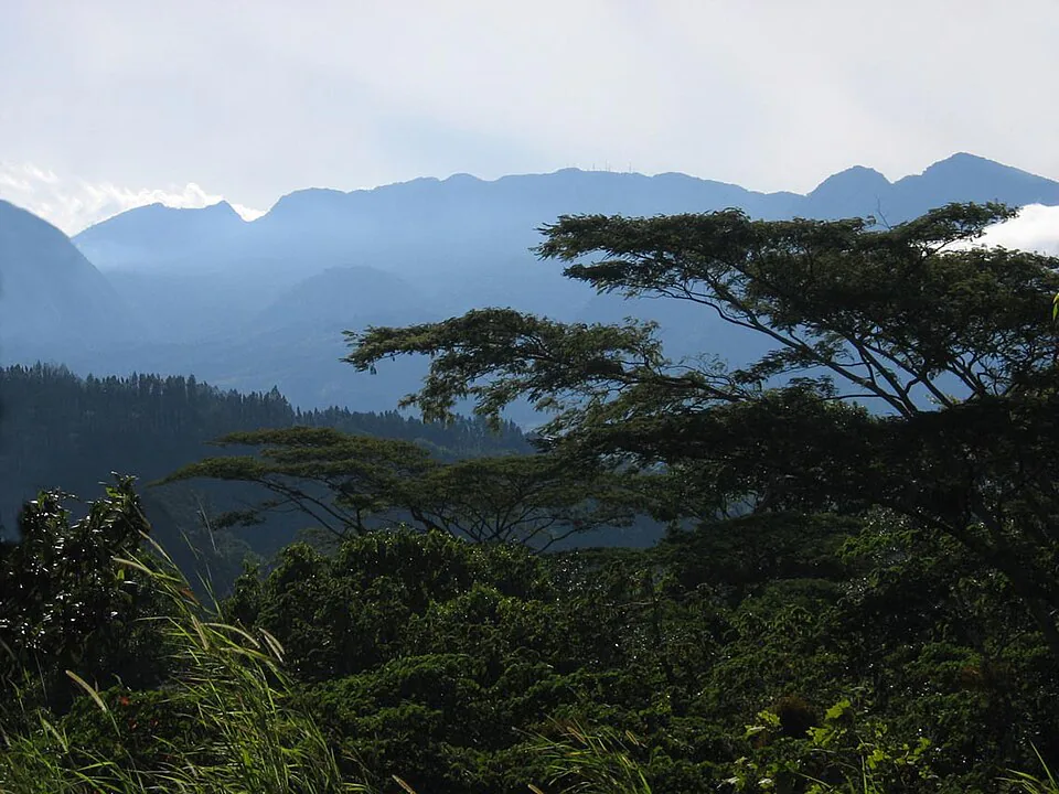
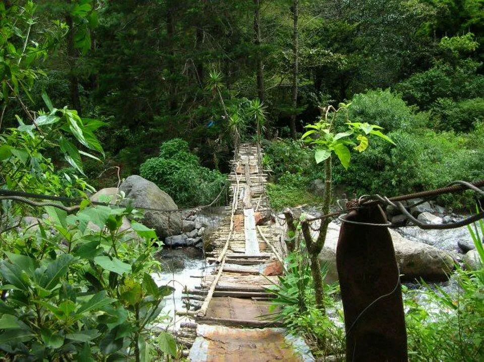
Sendero Los Quetzales is the most spectacular full-day hike in the Boquete area and one of the best hikes in all of Panama. The trail traverses the flank of Volcán Barú through primary cloud forest inside Volcán Barú National Park, connecting the town of Cerro Punta (on the Volcán side) with Boquete. Done in the Cerro Punta-to-Boquete direction, you gain around 600 m before a long descent of roughly 1,200 m — making the elevation profile much more forgiving than the reverse. The forest is extraordinary: ancient oaks draped in bromeliads, rivers crossing the path every few hundred metres, and quetzals in the canopy above the trail.
The numbers
- Distance: ~14 km one-way (Cerro Punta to Boquete)
- Elevation: Starts at ~2,200 m, peaks near 2,800 m, finishes around 1,000 m
- Difficulty: Moderate-hard — long day, significant elevation change, some technical sections near the high point; trail can be very muddy
- Time: 5–7 hours hiking; budget a full day including transport
- Fee: $5 national park entrance fee (paid at the Cerro Punta ranger station)
- Best season: December–April; the trail can be impassable in heavy rain due to river crossings
Logistics
Because it is a one-way trail, you need to arrange transport at both ends. The standard approach: take an early bus from David to Cerro Punta (2 hrs, ~$3.50) or arrange a private transfer from Boquete (~$45–$60 for the vehicle). Hike Cerro Punta to Boquete. A guide is strongly recommended — not because the trail is technically dangerous, but because junctions are poorly marked and it is easy to take a wrong fork. Guided tours from Boquete run $65–$100 per person and include transport to Cerro Punta. The trail passes through the Amistad International Park buffer zone, a UNESCO World Heritage Site.
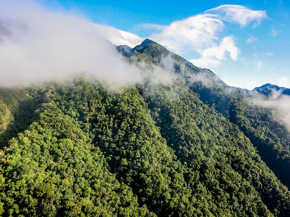
Section 06Volcán Barú summit hike
Volcán Barú is Panama's highest point at 3,475 m and the only place in the world from which — on a clear day — you can see both the Pacific Ocean and the Caribbean Sea simultaneously. That claim alone draws hikers from around the world. The summit hike from the Boquete side is one of the most physically demanding day hikes in Central America, with nearly 1,800 m of elevation gain over roughly 14 km. It is not technical climbing, but it is a long, relentless slog on a rough 4WD track through increasingly sparse vegetation.
The numbers
- Distance: ~14 km one-way from the park gate (28 km round trip)
- Elevation gain: ~1,800 m from the gate (gate sits at ~1,650 m; summit at 3,475 m)
- Difficulty: Very hard — sustained climb, high altitude, cold and wind near the summit
- Time: 6–8 hours up, 4–5 hours down; most hikers start between midnight and 2 am to reach the summit at sunrise
- Fee: $5 national park entrance (park gate opens at 4 am; for a midnight start, arrange access with a guide or the ranger station in advance)
- Best season: January–April; the summit is frequently cloud-covered in the wet season, eliminating the dual-ocean view
What to expect
The trail from the Boquete side follows a rough dirt road all the way to the summit — there is no singletrack. The first 6 km are through cloud forest and are the most pleasant. Above 2,800 m, the vegetation thins to elfin forest and then open rocky terrain. The summit itself is cluttered with telecommunications towers and a small shrine, but the 360-degree view — on a clear morning — is genuinely extraordinary. Temperatures at the summit can drop to 2°C–5°C even in the dry season. Wind chill makes it feel colder. Bring a warm layer, gloves, and a headlamp.
Guide requirement
A guide is not legally required, but it is strongly advised. The trail is straightforward in good weather, but summit conditions can change rapidly, and hypothermia is a real risk if you are underprepared. Guided Barú summit tours from Boquete cost $80–$150 per person and typically include transport, a guide, and basic equipment. Book at least a day in advance; tours fill up quickly in the dry season.
Section 07El Pianista, Piedra de Lino & the trails most guides miss
El Pianista Trail
El Pianista is the best free hike in Boquete. The trail starts 4 km from town in a residential neighbourhood, climbs through a narrow canyon-like path into full cloud forest, and reaches a mirador (viewpoint) at around 1,600 m before continuing deeper into the forest. The canyon section — steep walls, dripping vegetation, clouds literally passing through the trees — is unlike anything else in the area. Distance is approximately 8 km round trip with around 600 m of elevation gain. Allow 3–4 hours. There is no entrance fee, though some hikers report a small voluntary contribution box at the start. The trail is well-signed from the Boquete side. Turn back at the Mirador Pianista unless you are with a guide and have arranged transport on the far side.
Piedra de Lino (Cerro la Piedra de Lino)
A short, steep trail in the Los Naranjos neighbourhood that delivers panoramic views of Volcán Barú, the Bajo Mono valley, and Boquete town below. Distance is only 1.3 km one-way, but the 300 m elevation gain makes it feel harder than it looks. Allow 1.5–2 hours round trip. Free to access. Wear shoes with grip — the upper section is rocky and exposed. Best done in the morning before clouds build around the volcano.
Choclon Waterfall — the crowd-free alternative
Choclon is the trail that serious hikers mention quietly and most guides overlook entirely. Located about 40 minutes south of Boquete near the village of Caldera, the trail leads through a narrow gorge to twin waterfalls that fill a natural swimming hole. The hike is short (~4 km round trip, ~200 m gain) and the payoff — a secluded swimming hole with no entrance fee and almost no other tourists — is exceptional. The gorge section involves some easy scrambling over rocks. Best visited April–June when water levels are high but the trail is still passable. Getting there requires a taxi or your own transport to Caldera (~$15–$20 from Boquete).
Mossy Rock Trail (Sendero Musgo Rock)
A newer trail in the Jaramillo area, about 8 km from Boquete town, that passes through old-growth cloud forest to a 15-metre waterfall locals call La Dama de la Montaña. The forest here is particularly dense with orchids and medicinal plants. Distance is approximately 5 km round trip. Guided tours cost around $35 per person and are the easiest way to access it. The icy plunge pool at the base of the falls is, by local consensus, the coldest swimming hole in Chiriquí.
Section 08Seasonal conditions: which trails to hike and when
No competitor guide maps this out clearly, so here it is. Boquete has two seasons: dry (December–April) and wet (May–November). But the reality is more nuanced than that binary suggests.
| Month | Conditions | Lost Waterfalls | Pipeline / Quetzals | Los Quetzales | Volcán Barú |
|---|---|---|---|---|---|
| Dec–Feb | Dry, cool, some wind | Excellent | Excellent | Excellent | Best chance of views |
| Mar–Apr | Dry, warmer, quetzal nesting | Excellent | Peak quetzal season | Excellent | Good |
| May–Jun | Rains begin, waterfalls high | Muddy, ropes essential | Good, bring rain gear | Check river levels | Summit often clouded |
| Jul–Sep | Wet season peak | Slippery; upper falls may close | Passable | Possible closures | Not recommended |
| Oct–Nov | Heaviest rain | Challenging; check conditions | Passable | Possible closures | Avoid |
A few things the table cannot capture: even in the dry season, mornings in Boquete can be misty and trails damp from overnight cloud. Afternoons in the wet season often have clear windows between 6 am and noon. The best hiking window, year-round, is 6 am to 1 pm — start early, finish before the afternoon clouds build or the rain arrives.
Section 09Wildlife spotting: where and when to find the quetzal
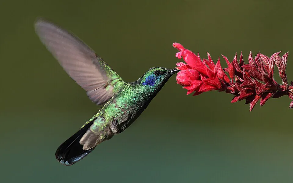
The Resplendent Quetzal is the reason many birders come to Boquete specifically. The male is unmistakable — emerald-green body, crimson chest, and tail feathers up to 65 cm long. Here is what the competitor guides do not tell you about actually finding one.
Best trails for quetzal sightings
The Pipeline Trail in Bajo Mono has the highest consistent sighting rate of any trail in the area. Multiple local guide groups operate here daily with spotting scopes, and independent hikers regularly encounter quetzals in the canopy — particularly in the section between the 1,000-year-old tree and the waterfall. Sendero Los Quetzales (the name is not accidental) is the other top-tier option, especially in the upper sections above 2,000 m. The El Pianista Trail and the upper sections of the Lost Waterfalls trail also produce sightings, though less reliably.
Best time for quetzal sightings
January to April is quetzal nesting season — the birds are most active, most visible, and most vocal. Within the day, 6 am to 9 am is the prime window. Quetzals feed on wild avocado fruit (aguacatillo) and are most active in the early morning. By mid-morning they tend to retreat higher into the canopy. Hiring a local guide with a spotting scope significantly increases your odds — they know the specific trees the birds return to.
Other wildlife
Howler monkeys are most reliably heard (and seen) on the Pipeline Trail and El Pianista, particularly in the early morning. Sloths are present on the Pipeline Trail — you almost certainly will not spot one without a guide's help; they are extraordinarily well-camouflaged. Hummingbirds are everywhere, year-round. The Volcano Hummingbird is endemic to the Barú massif and found nowhere else on Earth.
Section 10Getting to the trailheads: practical logistics
This is the section most guides skip. Here is exactly how to reach each major trailhead from Boquete town centre.
Colectivo minivans (cheapest option)
Colectivos depart from the corner of Avenida Central and Calle 1 Sur, one block north of Parque José Domingo Médica. Destinations are marked on the windscreen. The Bajo Mono route covers both the Pipeline Trail and Lost Waterfalls trailheads ($1.50, ~15 min). Colectivos run roughly every 20–30 minutes from around 6 am. They stop running in the early afternoon — plan your return accordingly, or arrange a taxi pick-up in advance.
Taxis
Taxis wait at Parque Central and outside the main bus terminal. Typical fares: Lost Waterfalls / Pipeline Trail $10–$15 one-way; El Pianista trailhead $5–$8; Barú National Park gate $15–$20; Caldera (Choclon) $15–$20. Always agree on the price before getting in. Many drivers will wait for you or arrange a return pick-up time — worth negotiating, especially for the Barú gate.
E-bikes — the smartest way to connect multiple trailheads
If you are planning a multi-trail day — say, the Pipeline Trail in the morning and a coffee farm visit in the afternoon — an e-bike is arguably the most efficient way to move between points in the Bajo Mono valley. The roads between Boquete town and the main trailheads are paved and scenic, with manageable gradients that an e-bike handles effortlessly. E-Valley Bikes operates guided e-bike tours out of Boquete that pair well with a hiking day — they know the roads, the trailheads, and the valley intimately. It is a genuinely different way to see the landscape between hikes.
Driving yourself
If you have a rental car, most trailheads have small car parks. You do not need a 4WD for the Lost Waterfalls, Pipeline Trail, or El Pianista trailheads. The Barú National Park gate road is rough but passable in a standard car in dry conditions; a 4WD is advisable in the wet season. Parking at the Lost Waterfalls is free; the Pipeline Trail car park charges a small fee (~$1).
Combining trails into a single day
The most efficient multi-trail day: Pipeline Trail + Lost Waterfalls. Both trailheads are within 1 km of each other in Bajo Mono. Start at the Pipeline Trail at 6 am (quetzal window), finish by 9 am, then walk or take a short taxi to the Lost Waterfalls entrance for a 9:30 am start. You will be back in town by 1 pm. A second strong combination is Piedra de Lino in the morning (views before clouds build) followed by an afternoon at a coffee farm — the Piedra de Lino trailhead in Los Naranjos is about 6 km from town and easily reached by colectivo or taxi.